

I always feel a bit dislocated when first exiting an underground public transport station, whatever city I am in. It always takes a minute or more to adjust and locate. There is the moment that occurs where you realise you can orient yourself and you know where you are going. Its the moment of becoming spatially located, but there is also the sense of locating in a place. The two are interrelated and the sooner one can do the second, the easier it is to do the first. But It takes time and familiarity to really know where you are located; to get a sense of the place around you and to bring it into your psyche. Recognition is required in order to feel at home in a place such that the feeling of being startled is only fleetingly noticeable.
The experience of emerging onto street level from the exits of the Central MTR in Hong Kong still, for me, provide a feeling of disruption that is noticeable. Exit C is particularly problematic. The exit is onto Des Voeux Road. The view itself has no depth as you are confronted with a billboard and a tall building. The old tricks learned in a childhood of looking for sun, wind direction, and and physical landscape do not work here as a means for orienting. These are rural knowledges. To get a sense of where the compass points of north, south, east and west are in relation to where you stand in an urban environment takes other forms of knowledge. One needs to be able to read the streets and the buildings in an urban place, just like one reads the sky and the physical geography in the rural.
One way to orient oneself upon arriving at street level from Exit C is to observe the trams running along the street. For this understanding It helps to know a bit of the history that makes this place. This street was the original shoreline of Victoria Harbour. Everything between Des Voeux Road and what is Victoria Harbour now is reclaimed land. What a different view there must have been from this spot when Hong Kong was first settled. From where you stand you would have seen across the Harbour to Kowloon. The expanse would have been quite big in those days as it took 40 minutes to cross on the Star Ferry (a trip that now takes about 10 minutes). This is a view toward the north, toward China. Behind you, and unseeable from this vantage, is The Peak, a place that at its heart was British as for many years only the colonial settlers were allowed to live there.
Looking toward the right you will see the large stores of the luxury designer brands. Most noticeable is Louis Vuitton across the intersection. That side of the street marks the distinctions between High End Hong Kong and the more accessible spaces of a more ordinary and older part of this city. Understanding who populates what appear to be anonymous buildings also helps to give understand and orientation to this place.
Across the street from exit C is World Wide House, within this mall space located in the upper pedestrian areas, you will not find the designer brands that characterise the buildings to the west. While Chung King Mansions in Tsim Sha Tsui has been identified as a hub of low end globalisation, World Wide House is Hong Kong’s hub of Cosmopolitanism-from-below. This building is the physical location through which many of the maids who come from Indonesia and The Philippines maintain their transnational linkages with home through the cash remitting, mailing and mobile phone services that are offered within the building. Employment agencies that connect maids with Hong Kong employers ensure that the flow back and forth, a requirement of a domestic helper visa, is maintained. The other businesses, which are mainly small shops selling foodstuffs, clothing, and crafted goods, provide glimpses of home, offer opportunities for maintaining community, and provide a space for news to travel from here and there. On any Sunday, which is the statutory rest day for the maids, thousands come to the street spaces around this building. They protest the injustices of their situation both in Hong Kong and in the Philippines, they offer support and community in what can otherwise be a hostile and lonely situation. They do this by sharing meals with friends, playing cards, dancing and singing, and sharing information as to how to get by in a culture that is not their own. In short they transform this anonymous space of global capitalism into a space of (extra)ordinary connection. Their presence and activities locate the view from Exit C within a wider space of flows and connections that extend beyond Hong Kong.
 To the left of Exit C, just a few hundred meters away, and beyond the intriguingly named but now defunct Theater Street are Fa Yuen Street East and West. These are permitted Hawker places and offer the opportunity to buy the low cost goods that once made Hong Kong a shopping mecca for the West. On sale are items one might find in places like the Lady’s Market in Mong Kok, or Stanley Market, on the other side of the island. Chinese style clothing and other goods, which would have once been visibly displayed upon the bodies of locals, but which now are reserved for tourists. Items appropriate to wear at home to display one’s travel, but not here in this place. Perhaps ironically then, this view to the west offers a vision of the more colonial aspects of the city. While early on Central district was an area that attracted both those from the Global East as well as the West, evidence suggests that at one point in its colonial history the area was designated as only for Westerners. Certainly the district was zoned for buildings that were identified as having a “western style”.
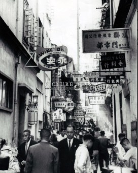
Chiu Lung Street, Photograph from the collection of Picture This, taken in 1967
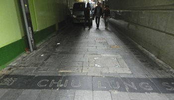
Chiu Lung Street in 2013
Unfortunately, I could find little information about the history of specific streets in this area of Hong Kong. The lettering at the entrance of what was once Theatre Street and Chiu Long Street remain, but what was on those streets has long been erased, as is the case for much of Hong Kong. There are moments of history discernable in the fabric of this landscape, but in a city that is forever looking forward, or as Akbar Abbas argues a city without nation and the associated imagined communities that arise out of national identity, the lack of memory is not surprising. This paradox is also why, I think, one never is quite certain where one is in Hong Kong. That in this place there will always remain a feeling of uncertainty, of being startled, which arises out of a lack of memory.

The Star Ferry web site is quite interesting and provides a bit of history on the harbour crossing. You can find their web site here.
If you are interested in photographs of old Hong Kong, Picture this has a wonderful selection for sale. You can find their web site here.
Note also that Google maps places Exit C on the opposite site of the road to where it actually is, adding further to the confusion upon exit.
This post was entered into the WordPress Weekly Photo Challenge on 1 June 2013. The Challenge was “The sign says”. You can find that challenge and other entries here. It was re-entered as a stop-gap for a challenge called letters. You can find that challenge here.
How to reference this post in non-web publications. If you would like to cite this post I suggest the following format:
Blake, M (2013) Findinf location: Central station, Exitit C of the Hong Kong MTR https://geofoodie.org/2013/03/30/exit_c/ Geofoodie.org 30 March 2013 (Accessed: XX/XX/20XX)
Related articles
- 10 things to truly feel Hong Kong as a traveler, not a tourist! (littlelittlebeanie.wordpress.com)
- Hong Kong domestic workers lose residency case #Vaw #migrantworkers (kractivist.wordpress.com)
- Things to do in Hong Kong – Central and Western HK by Mun Yin Liu (triptipping.com)

Pingback: Weekly Photo challenge – Letters – Clear message |
Pingback: Letters : Vector of emotions | parislux
Pingback: Weekly Photo Challenge: Letters (Lois and Lyno) | Chris Breebaart Photography / What's (in) the picture?
Pingback: I too… | Words & Pics
Pingback: Weekly photo challenge – Letters – Signed |
Pingback: Weekly Photo Challenge: Letters | Nola Roots, Texas Heart
thanks, this was really helpful as i was confused by google’s placement of exit c and another site which mentioned an exit c1.
Glad it was helpful! Thanks. For leaving a comment. The exit that is indicated on google maps is actually the exit for Hong Kong station, which is on another line, not Central station, which is the one more widely used. Central station’s exit C is not indicated on the map.
Pingback: Weekly Photo Challenge: The Sign Says (Sign Revisited) | What's (in) the picture?
Pingback: Weekly Photo Challenge: The Sign Says (Puerto de las Palomas) | What's (in) the picture?
Pingback: Weekly Photo Challenge: The Sign Says (What happened to faith?) | What's (in) the picture?
Pingback: Weekly Photo Challenge: The Sign Says | Endless Skys
Pingback: Weekly Photo Challenge: The Signs Say (My Name! Well, almost) | What's (in) the picture?
Pingback: Weekly Photo Challenge: The Sign Says | Life of 24 Hours
Pingback: Weekly Photo Challenge: Sign Says – Trial 2 – Welcoming the Meter Readers! | Bastet and Sekhmet
Pingback: Weekly Photo Challenge: Signs | blogagaini
Pingback: Weekly Photo Challenge: The Sign Says (bicycles go where?) | What's (in) the picture?
Pingback: Weekly Photo Challenge: The Sign Says (bicycles go where?) | What's (in) the picture?
Pingback: Weekly Photo Challenge: The Sign Says (Bibracte and Julius Caesar) | What's (in) the picture?
Pingback: Weekly Photo Challenge: Signs – The Shoe Store | Bastet and Sekhmet
Pingback: Weekly Photo Challenge: The Cowboy Sign Says | Humbled Pie
Pingback: Weekly Photo Challenge: The Cowboy Sign Says | Humbled Pie
Pingback: Visiting Hong Kong–Things I would do if I were coming to visit. | GeoFoodie